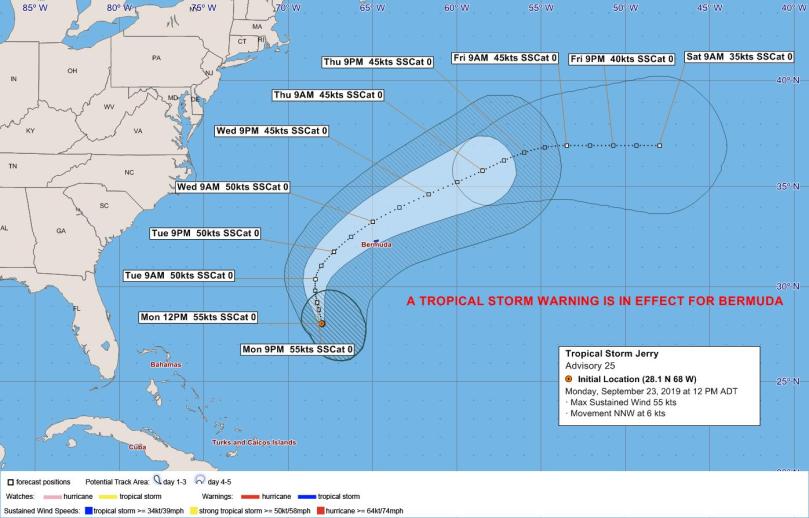
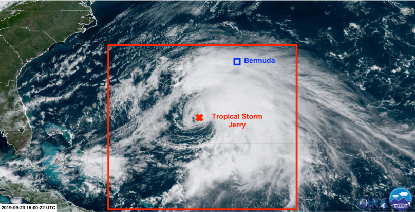
Not a week after Hurricane Humberto’s strike, Tropical Storm Jerry is a threat to Bermuda with a Tropical Storm Warning in effect. Tropical Storm conditions are expected in Bermuda as Jerry nears and passes the island sometime between Tuesday evening and much of Wednesday morning. However, impactful weather is expected well in advance of the closest approach of the storm, with the outermost rainbands moving in as early as late this afternoon with strong easterly winds.
Today through Tuesday Morning
Forecast: Moderate to strong easterly winds veer southeasterly this evening and overnight. Occasional showers or periods of rain. Then strong southeasterly winds with gusty, possibly thundery showers and periods of rain Tuesday morning.
The midday update from the National Hurricane Centre finds Jerry 345 miles southwest of Bermuda, moving slowly north-northwestward at 7 mph. Jerry currently has maximum sustained winds near 65 mph and a minimum central pressure near 991 hPa.
Jerry remains in an environment dominated by strong vertical wind shear. The upper-level flow is from the southwest, while the low-level flow is from the southeast. This change in wind direction with height is forcing all of the inclement weather to remain over the eastern half of the storm, limiting organisation and therefore preventing strengthening despite Jerry being over high sea surface temperatures of 28-29°C.
Jerry is generally moving slowly north-northwestward into a break in the sub-tropical ridge. This general motion is expected to continue over the next 24 hours.
On a technical note, a cluster of deep convection near the center of Jerry appears to be keeping the cyclone vertically coupled. As a result, Jerry is steered by a vector-average of the southeasterly low-level flow and southwesterly upper-level flow. The east-west components of the flow at these two levels roughly cancel, leaving a net southerly flow across the cyclone and a storm motion toward the north. Whenever the convection wanes, the low-level circulation becomes decoupled, follows the low-level flow, and drifts more northwestward. Whether Jerry can maintain the deep convection will determine how far to the west the storm drifts. This will have a knock-on effect for the timing (i.e. a drift further west could delay impacts) and potentially the severity of impacts to Bermuda (i.e. a more vertically-coupled cyclone could be stronger). Convection is currently waning over the centre.
Tuesday Morning through Wednesday
Forecast: Strong southeasterly winds veering southerly and increasing to tropical storm force (> 38 mph) by Tuesday evening. Showers, some thundery, become more frequent with tornado potential (always possible with nearby Tropical Cyclones). Winds veer westerly as Jerry passes in the pre-dawn hours of Wednesday morning. At its peak, expect strong tropical storm conditions with hurricane force (>73 mph) gusts in elevated and exposed locations. Conditions then quickly improve on Wednesday with tropical storm conditions subsiding by late morning.
The strong vertical wind shear is expected to diminish somewhat as the upper-level trough cuts off forming an upper-level low which backs away to the west in the 18-36 hour timeframe. As this occurs, the upper-level winds across Jerry decrease and the flow pattern becomes more diffluent. This could result in some short-term strengthening, but it is on the whole unclear whether Jerry will be able to take advantage of this short window of more favourable conditions. The most likely outcome is that Jerry maintains its intensity but restructures, and this is what the National Hurricane Center calls for.
After 36 hours, the deep layered flow shifts out of the west in response to a deepening trough over Atlantic Canada, steering Jerry eastward then accelerating northeastward. The centre of Jerry is expected to pass less than 100 nautical miles away from Bermuda in the pre-dawn hours of Wednesday morning.
Continue to regularly check for the latest official forecast information from the National Hurricane Centre and the Bermuda Weather Service.
